Weather Monitoring: Advanced Climate Data Collection for Rural Farming
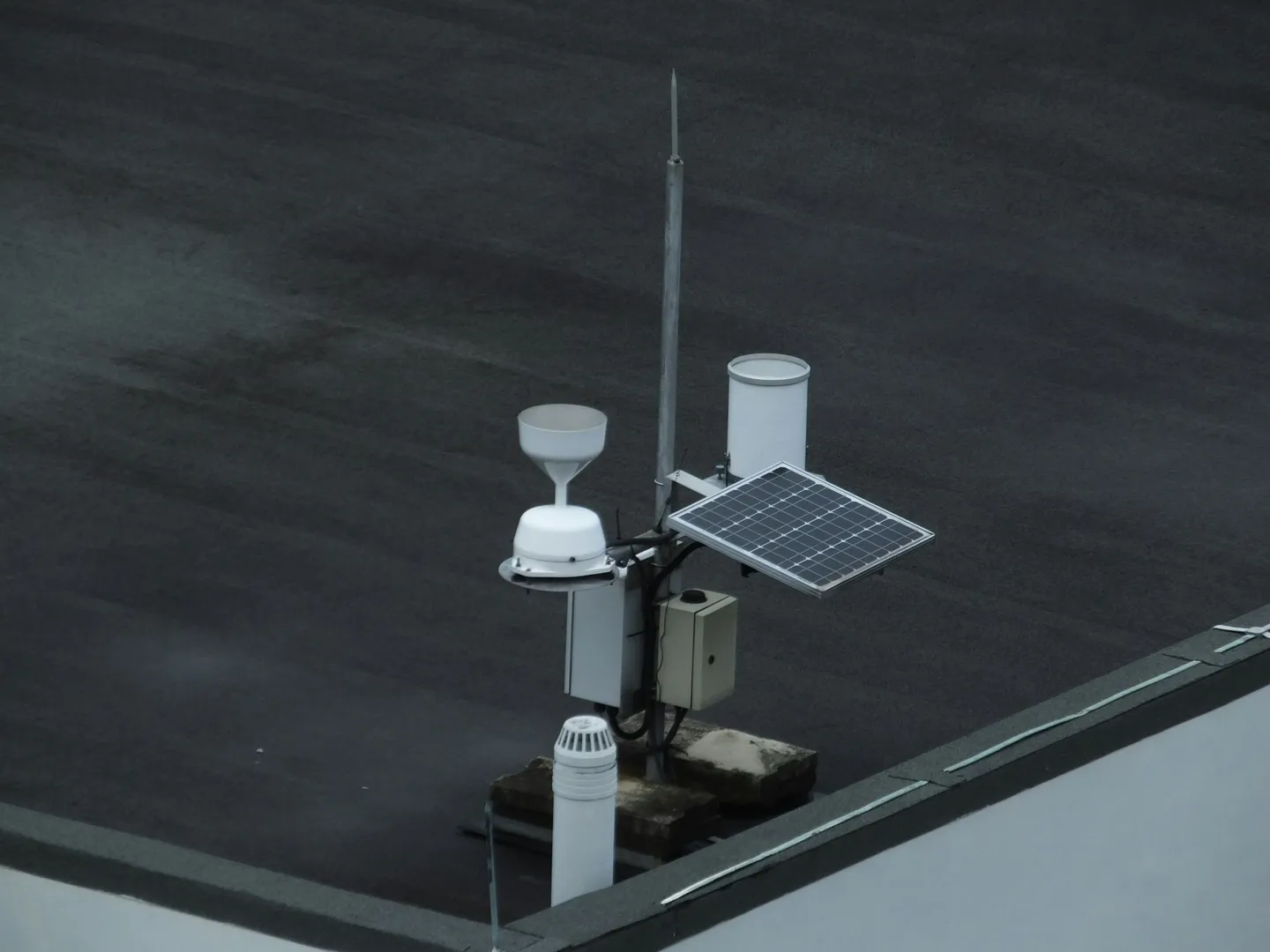
Photo by Abhinav Chitikela on Unsplash
Agricultural weather monitoring has come a long way from basic thermometers. Today’s sensor networks give farmers detailed, real-time data that directly affects whether a season ends in profit or loss. The global agriculture sensors market is expanding from $4.81 billion in 2025 to a projected $9.32 billion by 2032, driven by farmers who recognize that weather monitoring delivers 150-200% return on investment within one to two growing seasons.
From Consumer Stations to Research-Grade Networks
The agricultural weather monitoring market offers solutions spanning every budget and technical requirement. Davis Instruments’ Vantage Pro2 GroWeather Systems dominate the consumer segment with their 2.5-second update intervals and wireless transmission reaching 1,000 feet. These workhorses withstand 200 mph winds while measuring temperature, humidity, wind parameters, rainfall, barometric pressure, and solar radiation for evapotranspiration calculations—all the essentials for informed farm management decisions.
Moving up the technology ladder, Campbell Scientific’s ClimaVue50 represents the gold standard in professional monitoring. This all-in-one sensor captures air temperature, relative humidity, vapor pressure, barometric pressure, wind characteristics, solar radiation, precipitation, and even lightning strikes. Operating on less than 1 milliamp at 12 volts enables solar-powered deployment in remote locations, functioning reliably from -40°C to +70°C—critical for farms spanning diverse microclimates.
The biggest change comes from IoT integration, exemplified by CropX’s comprehensive agronomy platform. Their patented spiral-design soil sensors penetrate multiple depths to measure moisture, temperature, electrical conductivity, and salinity, while pioneering real-time actual evapotranspiration sensors provide unprecedented water management insights. The telemetry devices supporting cellular connectivity and third-party sensor integration operate season-long with minimal maintenance, transforming how farmers understand their fields’ water dynamics.
LoRaWAN technology has emerged as the connectivity backbone for rural agricultural applications. With transmission ranges reaching 15 kilometers and packet loss below 1% at 500 meters, this long-range, low-power network architecture enables farmers to deploy distributed sensor networks across vast properties without infrastructure investments that would have been prohibitive just a decade ago.
The Science Behind Agricultural Data Collection
Modern agricultural weather monitoring goes beyond simple measurement. The goal is turning continuous data streams into decisions farmers can act on. Automated IoT systems gather readings every 10-15 minutes, transmitting hourly summaries using MQTT protocol for minimal bandwidth consumption or REST APIs for seamless web integration with existing farm management platforms. This constant flow of information transforms reactive farming into proactive management.
Standardization has finally solved the Tower of Babel problem in agricultural data. AgGateway’s ADAPT Standard Version 2.0, released in June 2024, provides a universal schema for agricultural production data exchange in JSON, GeoParquet, and GeoTiff formats with UTC timestamps. Farmers no longer need custom conversion plugins between different manufacturers’ systems—data flows seamlessly from sensors to software to machinery, regardless of brand.
Growing Degree Days calculations remain fundamental to crop management despite all the technological advances. The formula—GDD = [(Maximum Temperature + Minimum Temperature) ÷ 2] - Base Temperature—might seem simple, but its applications are profound. Corn farmers using a 10°C base temperature with a 30°C maximum cap can predict harvest timing within days, track pest development cycles, and optimize input applications with remarkable precision.
Evapotranspiration modeling using the Penman-Monteith equation has changed how farmers manage water. By incorporating air temperature, solar radiation, wind speed, relative humidity, and atmospheric pressure, farmers calculate reference evapotranspiration (ET₀) and apply crop-specific coefficients to determine actual water requirements. Real-time irrigation scheduling based on ET calculations achieves 10-30% water savings while maintaining or even improving yields—a critical advantage as water becomes increasingly precious.
Machine learning is making forecasts considerably more accurate. IBM’s Temporal Fusion Transformer improves extreme rainfall prediction up to six months ahead, while their Watson Decision Platform provides AI-powered insights across 2.2 billion forecast locations updated hourly. These hyperlocal predictions achieve 3-4 kilometer radius accuracy, enabling farmers to make field-specific decisions with confidence previously reserved for much larger geographic scales.
Strategic Sensor Placement and Infrastructure
The difference between useful data and misleading measurements often comes down to installation details. Following NOAA and WMO guidelines, temperature and humidity sensors must be mounted 1.25-2 meters above ground, with 1.5 meters as the international standard. Wind sensors demand 10-meter elevation for accurate readings, while rain gauges perform optimally at 1.2-1.5 meters height. The critical distance rule—sensors positioned at least four times the height of nearby obstructions for temperature and ten times for wind—means that 20-foot tree requires 80 feet clearance for temperature measurements and 200 feet for wind sensors.
Rural properties present unique power challenges that solar systems elegantly solve. A 10-20 watt panel paired with deep-cycle 12V batteries typically provides 7-14 days of backup power, ensuring continuous operation through extended cloudy periods. LiFePO4 batteries increasingly replace traditional lead-acid systems, offering superior performance in extreme temperatures and lifespans extending beyond a decade—crucial for remote installations where maintenance visits are costly.
Lightning protection cannot be an afterthought in rural installations where structures often represent the highest points for miles. Proper grounding requires copper-clad steel ground rods at minimum 5/8-inch diameter and 8 feet length, achieving ground resistance below 10 ohms. Installing ground rods 8-10 feet from equipment, perpendicular to wire runs, using 6-12 AWG copper wire creates a robust protection system. Combined with surge protection devices on all data and power lines, this investment prevents catastrophic failures that could destroy thousands of dollars in equipment during a single storm.
The choice between DIY and professional systems involves careful consideration of accuracy needs, budget constraints, and technical capabilities. Consumer stations like the Ambient Weather WS-2902 at $200-300 offer WiFi connectivity and Weather Underground integration with ±1°C temperature and ±5% humidity accuracy—sufficient for many farming applications. Professional systems from Campbell Scientific costing $8,000-15,000 provide research-grade accuracy of ±0.1-0.2°C with sensor lifespans extending 10-15 years, justifying their investment for high-value crops or research applications.
Seamless Integration with Modern Farm Operations
Weather monitoring becomes most useful when data flows into existing farm management systems. ISOBUS-compatible systems like Trimble’s Field-IQ deliver real-time weather data directly to tractor displays via ISO 11783 protocol. Their ultrasonic wind sensors eliminate moving parts that fail in dusty conditions, while automatic Delta T calculations ensure optimal spray applications. This plug-and-play compatibility works with any ISOBUS-certified terminal, automatically saving data to farm records through Task Controller functionality—transforming every field operation into a documented, weather-informed decision.
Remote monitoring capabilities have evolved far beyond simple data logging. Davis Instruments’ EnviroMonitor platform manages up to 50 wireless sensors per network with over 400 possible sensor combinations. Cloud-based dashboards accessible through iOS and Android apps deliver customizable alerts for frost warnings, irrigation triggers, and disease pressure thresholds. Farmers receive notifications before problems develop, not after damage occurs.
Weather-triggered automation turns reactive management into systems that operate on their own. Automated irrigation systems adjust schedules based on evapotranspiration calculations and soil moisture levels, implementing deficit irrigation strategies that optimize water use efficiency. Greenhouse control systems respond to temperature and humidity thresholds for ventilation and climate control without human intervention. When temperatures approach freezing, frost protection systems automatically activate sprinklers or wind machines, protecting vulnerable crops during critical hours when farmers might otherwise be asleep.
The power of collaborative monitoring shines through networks like the Community Collaborative Rain, Hail & Snow Network (CoCoRaHS), where 27,000+ active observers across North America share daily precipitation measurements. This grassroots data supports the National Weather Service, USDA, emergency managers, and researchers while providing farmers with regional context for their local observations—proving that weather monitoring’s value multiplies when shared.
Financial Returns That Justify Investment
Weather monitoring pays for itself at every scale of investment. Entry-level systems from $200-400 provide essential monitoring capabilities that prevent basic weather-related losses. Mid-range solutions like the KestrelMet 6000 AG at $999 include comprehensive weather monitoring with cellular connectivity, eliminating the need for dedicated internet infrastructure. Professional systems exceeding $10,000 deliver research-grade accuracy with advanced automation capabilities that transform large-scale operations.
Real-world returns consistently exceed expectations across diverse farming operations. An Australian wheat farm achieved 200% ROI through 25% fertilizer reduction plus 15% yield increases within a single season. NASS research documents average additional revenue of $43.40 per acre from 4.3 bushel per acre corn yield improvements. A 1,000-acre Midwest operation reported 150% ROI combining 12% yield increases with 10% cost reductions. The NEWA network’s 400+ weather stations across 15 states generates average annual savings of $33,048 from avoided crop losses plus $4,329 from reduced pesticide applications, with 75% of growers reporting decreased spray costs.
Government support dramatically improves investment economics. The USDA’s Environmental Quality Incentives Program provides up to $450,000 per contract with 75% cost-share for weather monitoring systems integrated into precision agriculture practices. With $2.8 billion available for FY2025 through Inflation Reduction Act funding, farmers have unprecedented access to implementation support. The Conservation Stewardship Program adds another $943 million for technology upgrades enhancing existing conservation efforts.
Parametric insurance products provide automatic payouts based on weather triggers. Claims process in days rather than months, improving cash flow during critical recovery periods. Traditional crop insurance providers offer premium reductions of 10-30% for farms with comprehensive weather monitoring data, recognizing the reduced risk profile of data-driven operations.
Learning from Agricultural Weather Monitoring Pioneers
The Northeast Weather Association network demonstrates how regional cooperation multiplies individual benefits. With station investments of $800-2000, participants across apple, grape, onion, and potato operations save an average of $33,048 annually in avoided losses plus $4,329 in reduced chemical costs. Payback periods measured in months rather than years validate the investment for even small-scale producers.
Steven Hobbs at Yarrock Farm calls their Davis Instruments weather stations “the most used piece of equipment on the farm”—high praise from someone who owns hundreds of thousands of dollars in machinery. The stations fundamentally changed business operations, optimizing everything from planting schedules to harvest timing and storage management. That shift from intuition-based to data-driven decisions reflects how farming has changed.
WiseConn’s DropControl System achieves 30% water savings through sophisticated correlation of soil moisture and weather data. By automating irrigation based on real-time field conditions rather than calendar schedules, the system reduces both over and under-watering risks while freeing farmers from constant manual monitoring—proving that technology enhances rather than replaces agricultural expertise.
Michigan’s 2012 cherry disaster offers a sobering reminder of weather’s destructive potential. Unseasonably warm winter temperatures triggered premature budding, followed by killing frosts that destroyed $220 million in cherry crops. Growers with comprehensive monitoring systems and automated frost protection significantly reduced losses through timely protective measures—a stark contrast to those relying on regional forecasts and manual observations.
Adapting to Climate Volatility Through Data
Climate adaptation is no longer a future concern. It is a present one. Farmers increasingly rely on 30+ year climate records to adjust cropping patterns, with USDA Climate Hubs documenting optimal planting windows shifting by 1-2 weeks across many regions. The Agricultural Research Service integrates climate priorities into 5-year Action Plan cycles, developing drought-tolerant and heat-resistant varieties that farmers select based on projections showing increased temperature and precipitation variability.
The National Integrated Drought Information System operates eight regional Drought Early Warning Systems, providing observation, monitoring, prediction, and forecasting capabilities that transform drought from surprise to managed risk. The US Drought Monitor’s categories from D0 (Abnormally Dry) through D4 (Exceptional Drought) trigger USDA disaster programs including the Livestock Forage Disaster Program, providing critical support during extreme events that would otherwise devastate rural communities.
Livestock management increasingly depends on Temperature-Humidity Index calculations, with dairy cattle experiencing mild stress at THI 72-79 and severe stress above 84. Heat stress currently causes $1.2 billion in annual dairy losses, projected to reach $40 billion annually across all livestock sectors as temperatures rise. Automated monitoring systems using AI-powered behavior analysis and thermal imaging provide early stress identification, enabling proactive interventions that maintain productivity despite challenging conditions.
Digital Platforms Multiplying Weather Data Value
Modern farm management software transforms raw weather data into strategic intelligence. Climate FieldView from Bayer combines weather monitoring with field mapping, planting records, and harvest data, providing real-time insights through satellite imagery and variable rate application maps. Compatibility with John Deere, Case IH, and other major manufacturers ensures data flows seamlessly from sensors through software to machinery, creating a closed loop of information and action.
FarmLogs simplifies weather tracking for smaller operations, integrating field activity logging with yield predictions based on historical weather correlations. Mobile optimization delivers real-time alerts and field condition updates directly to farmers’ phones, while cost analysis features quantify weather impacts on profitability—critical information for loan applications and crop insurance documentation.
Enterprise operations rely on platforms like Granular from Corteva Agriscience, which provides advanced analytics showing weather impacts on operational budgets and cash flow projections. Access to a century of weather data enables trend analysis that identifies long-term patterns invisible in shorter datasets. Agricultural consultants leverage these professional features to manage multiple clients, multiplying expertise across thousands of acres.
Mobile applications extend monitoring capabilities into farmers’ pockets. Weather Underground’s hyperlocal data from personal weather station networks provides neighborhood-level accuracy unavailable from official stations. Windy offers professional-grade visualization comparing ECMWF, GFS, NAM, and regional models side-by-side. MyRadar delivers real-time animated precipitation tracking with lightning detection and hurricane monitoring—critical for agricultural regions facing severe weather threats.
Historical Patterns Guiding Future Decisions
Effective seasonal planning requires synthesizing multiple data streams into coherent strategies. NOAA Climate Data Online provides access to weather records dating to 1945, which USDA agencies use for crop insurance rate-making and disaster program verification. State climatology offices collaborate with NRCS to develop county-level climate profiles for conservation planning, providing 10-30 year baselines that guide crop selection and infrastructure investments.
The National Agricultural Statistics Service employs sophisticated predictive methods using historical weather data to improve forecasting accuracy. Their Weekly Weather and Crop Bulletin showing winter wheat harvest at 53% compared to the 54% five-year average demonstrates how real-time conditions compare to historical patterns. These comparisons enable farmers to anticipate whether seasons will run early or late, adjusting labor and equipment scheduling to match actual rather than calendar-based timing.
Irrigation scheduling using the checkbook method combines soil moisture data with daily crop water calculations for precise timing. Consider a 36-inch soil profile with 3.12 inches available water capacity and 50% management allowable depletion permitting 1.56 inches depletion before irrigation. With current depletion at 1.08 inches and 0.2 inches daily evapotranspiration, irrigation should occur in approximately two days—precision impossible without continuous monitoring.
Early Warning Systems for Agricultural Threats
Modern weather monitoring provides critical lead time for extreme event preparation. Frost monitoring systems deliver 12-72 hour predictions with field-specific accuracy, using minimum temperature thresholds for different crop growth stages combined with radiative cooling calculations for clear nights and inversion layer detection algorithms. Automated SMS and mobile app alerts trigger at customizable temperature thresholds, activating wind machines and irrigation systems that prevent millions in potential losses.
The convergence of soil moisture sensors with weather monitoring creates comprehensive water management systems. Capacitance sensors costing $250-350 provide fast response with remote capabilities, while TDR sensors deliver superior accuracy with minimal calibration needs. Installing sensors at one-third and two-thirds of root zone depth across multiple field locations captures the spatial variability essential for precision irrigation management.
Management Allowable Depletion typically ranges from 30-50% of available water capacity, balancing yield optimization with water conservation. Field capacity calculations using volumetric water content measurements taken 12-24 hours after irrigation establish baseline moisture levels. Continuous monitoring identifies stress conditions before visual symptoms appear, while threshold alerts prevent yield-limiting water deficits that could otherwise go unnoticed until irreversible damage occurs.
Maintaining Data Integrity Through Best Practices
Data reliability depends on systematic calibration and maintenance procedures often neglected after initial installation. Annual calibration should verify temperature against NIST traceable thermometers, humidity using saturated salt solutions, pressure referencing local airports or National Weather Service stations, wind speed with portable reference anemometers, and rain gauge accuracy using measured water volumes. These procedures maintain the measurement precision that management decisions depend upon.
Monthly maintenance prevents most common failures. Cleaning rain gauge funnels removes debris that causes undermeasurement. Inspecting solar panels ensures adequate charging capacity. Checking battery voltage prevents unexpected shutdowns. Verifying data transmission confirms continuous operation. These simple tasks, often taking less than 30 minutes, prevent data gaps that could compromise an entire season’s records.
Automated quality control procedures flag impossible values, implement rate-of-change limits preventing sensor spikes, perform consistency checks between related parameters, and interpolate missing data to maintain continuous records. Manual review identifies patterns automated systems miss, while comparison to nearby stations ensures regional consistency. The NEWA network’s quality control protocols demonstrate how systematic verification maintains data integrity across hundreds of stations.
Navigating Support Programs and Resources
Government support extends far beyond direct financial assistance. The Joint Agricultural Weather Facility, collaborating between NOAA/NWS and USDA, provides free forecasts and agricultural assessments through the Weekly Weather and Crop Bulletin. NOAA Climate Services delivers earth observation data from GOES satellites and Automated Surface Observing Systems specifically formatted for agricultural applications.
State extension programs provide invaluable training and technical assistance. Pennsylvania’s Agricultural Innovation Grant program offers $10 million with $7,500-$50,000 planning grants requiring only 30% match. California’s Climate Smart Agriculture grants support weather monitoring within comprehensive adaptation strategies. These programs recognize that technology without education rarely achieves its potential.
Private sector support complements government programs. The AGCO Agriculture Foundation provides $400,000-$450,000 per project focusing on youth-led innovations for farmers ages 18-40. Regional Sustainable Agriculture Research and Education grants offer up to $25,000 for individual projects and $29,000 for collaborative efforts. These diverse funding sources ensure that financial constraints need not prevent weather monitoring implementation.
Your Weather Monitoring Implementation Strategy
Beginning a weather monitoring program requires honest assessment of operational needs and growth ambitions. High-value specialty crops justify intensive monitoring that might seem excessive for commodity grains. Properties with significant topographic variation demand multiple monitoring points capturing microclimate differences that affect everything from frost risk to disease pressure.
Start with your most valuable or climate-sensitive fields, where return on investment appears fastest. A mid-range system like the Davis Vantage Pro2 at $600-1200 provides professional-grade accuracy with proven reliability and extensive support resources. Install according to NOAA guidelines—proper siting, grounding, and power systems ensure the accurate, continuous operation that transforms data from interesting to actionable.
Expand monitoring systematically based on documented returns rather than assumptions. Add soil moisture sensors where irrigation optimization provides measurable benefits. Deploy additional weather stations to capture microclimate variations affecting specific management decisions. Integrate specialized sensors addressing particular challenges—leaf wetness for disease prediction, canopy temperature for stress detection, or UV sensors for fruit quality management.
Maximize available financial assistance by applying for EQIP funding during November application windows, potentially securing 75% cost-share for comprehensive monitoring systems. Document weather data impacts on yields and costs to justify expansion to lenders, landlords, or skeptical family members. Participate in regional weather networks to access shared expertise while contributing to community resilience—remembering that agriculture’s collaborative tradition extends to data sharing.
Getting Started
Weather monitoring has become a practical necessity as climate variability increases and precision agriculture becomes standard practice. Affordable sensors, reliable connectivity, better analytics, and government support programs make implementation accessible regardless of operation size or technical expertise. With documented returns of 150-200% within two seasons, weather monitoring is one of the more reliable technology investments a farm can make.
The benefits compound over time. Optimized input timing reduces costs while improving results. Weather-informed decisions prevent losses that hit unmonitored operations hard. Better crop quality commands higher prices. As one grower put it: “After the first season with proper weather monitoring, I couldn’t imagine farming without it.”
For farmers weighing the investment, the practical question is not whether weather monitoring is worth it, but how quickly they can get a system in place and start collecting data.